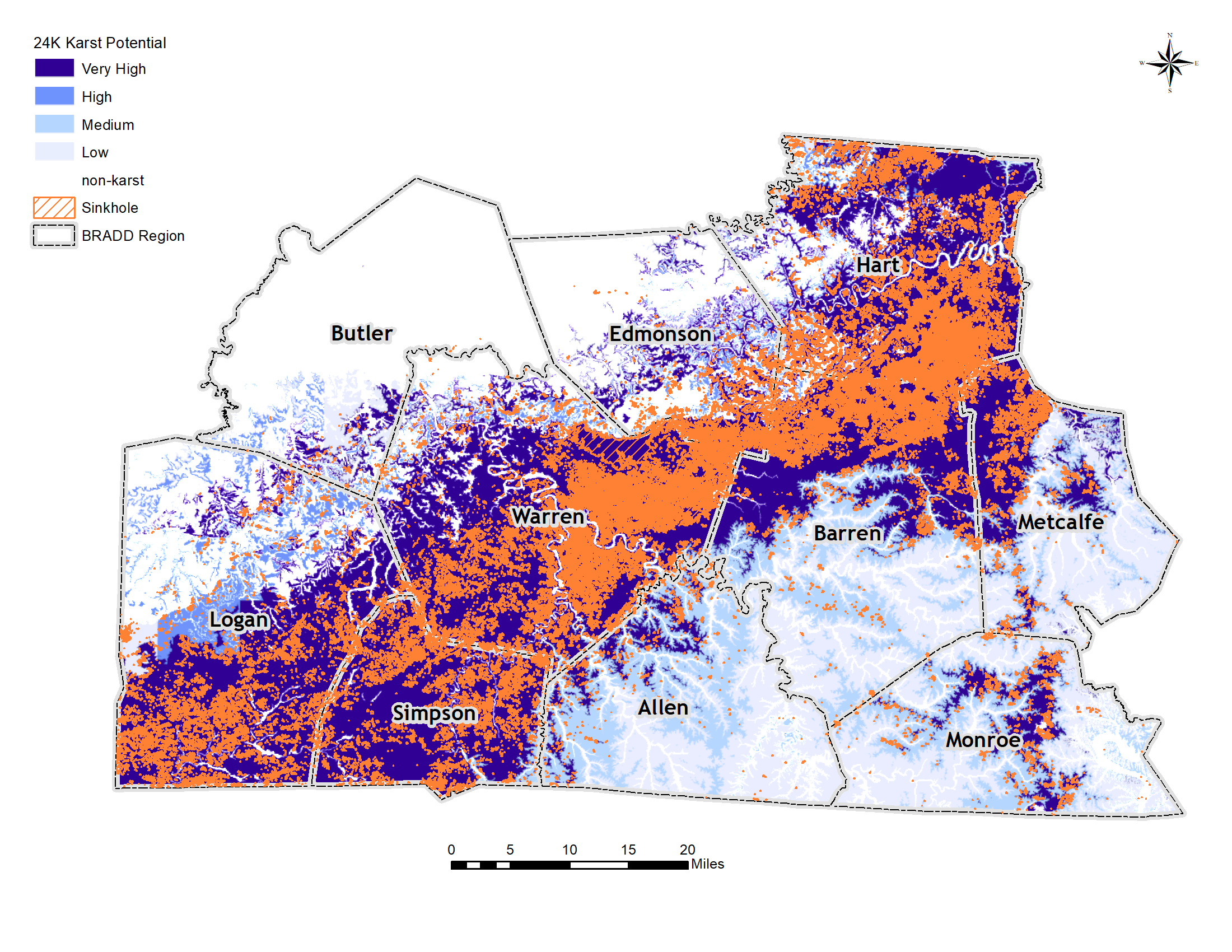
Karst / Sinkhole

Karst refers to a type of topography formed in limestone, dolomite, or gypsum by dissolution of these rocks by rain and underground water, and is characterized by closed depressions or sinkholes, and underground drainage. During the formation of karst terrain, water percolating underground enlarges subsurface flow paths by dissolving the rock. As some subsurface flow paths are enlarged over time, water movement in the aquifer changes character from one where ground water flow was initially through small, scattered openings in the rock to one where most flow is concentrated in a few well developed conduits. As the flow paths continue to enlarge, caves may be formed and the ground water table may drop below the level of surface streams. Surface streams may then begin to lose water to the subsurface. As more of the surface water is diverted underground, surface streams and stream valleys become a less conspicuous feature of the land surface, and are replaced by closed basins. Funnels or circular depressions called sinkholes often develop at some places in the low points of these closed basins.

Solution Sinkholes are formed by the weathering by dissolution of exposed soluble bedrock (limestone, dolomite, marble, and rock salt) at the land surface. Surface water collects in the natural depressions and slowly dissolves a sinkhole.


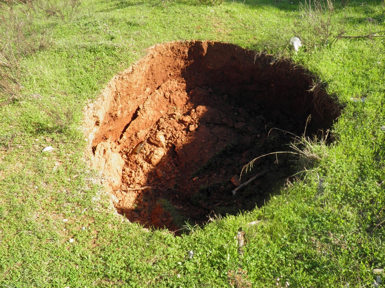
Collapse Sinkholes form when the surface materials suddenly sink into a subsurface cavity or cave. Cavities form slowly over time as groundwater moves along fractures in soluble bedrock which enlarges them through dissolution. Collapses may occur when the cavity gets sufficiently large and the “roof” becomes too thin to support the weight of any overlying rock or sediment causing the cavity to collapse; or if groundwater levels are lowered causing the overlying sediment to first erode and then collapse into the dewatered cavity.


Subsidence Sinkholes – Similar to solution sinkholes, except the soluble bedrock is covered by a thin layer of soil and/or sediment. Surface water infiltration dissolves cavities where the bedrock is most intensely fractured resulting in the overlying sediment to gradually move downward into the expanding cavity. Sinkhole collapse is the hazard most commonly associated with karst. This hazard occurs in the soil that lies on top of soluble bedrock.

The Kentucky Geological Survey (KGS) identifies two ways in which sinkholes collapse:

  1. The roof of a cave becomes too thin to support the weight of the material above it and collapses.
  2. Limestone bedrock develops a fracture that is enlarged by water dissolving the limestone. As the limestone erodes, the soil above it slowly falls into the developing sinkhole. This type of cover-collapse is typically very slow and occurs over a long period of time. Only in rare instances will limestone bedrock dissolution cause a rapid collapse.

Karst-related hazards happen quickly and without warning. However, scientists have mapped a large portion of the BRADD region to determine where these hazards are most likely to occur. A snapshot of this mapping is located above. to view a fully interactive map and explore sinkholes by jurisdiction, click on the link below.

In February of 2014, the BRADD Region received national attention after the floor of the Corvette Museum in Bowling Green collapsed into a 30-foot deep sinkhole. At the time of the collapse, the damage to the facility and the eight corvettes that succumbed to the sinkhole was estimated at $3.2 million.

Other notable past events include a significant sinkhole collapse in 2002 on Dishman Lane in Bowling Green. Extensive repairs to the road cost $1 million.

More recently, after three days of extensive rainfall and flooding in 2021, a number of sinkholes occurred across farmland in Hart County. On one Hammonsville farm, a new 8-foot by 8-foot  sinkhole appeared near an existing sinkhole. Additionally, the existing sinkhole grew as a result of rainfall accumulation. New and exacerbated sinkholes on farmland pose a risk to livestock; a calf had to be rescued from the aforementioned sinkhole after falling in.

Sources:

Detroit Free Press, Hart County News-Herald 2021, Hart County News-Herald 2002

The dashboard linked below shows karst potential in the BRADD Region. Sinkholes are a quintessential feature of karst terrain, and the presence of karst terrain significantly increases a community’s risk to sinkholes. Moderate sinkhole or subsidence potential is defined as karst terrain where sinkholes have not presented themselves. Major sinkhole or subsidence potential is defined as karst terrain where 1-9 sinkholes per square kilometer have been recorded in the past.  As shown below, moderate and major karst potential is present in all BRADD counties. This, in part, is due to the many cave systems prominent throughout the region.

Overall, the BRADD Region ranks the probability of sinkhole occurrence as highly likely because of the extensive number of sinkholes identified in the region and moderate to high karst potential in each county. This was determined using the classification definitions outlined by FEMA (click here for more information).

Damages to human-made structures caused by sinkholes can range from minor to severe. Office buildings, homes, roads, utility lines, and other critical facility or structure located above a sinkhole could be affected. If the sinkhole is large enough, it can affect an entire building or home when it collapses. Minor sinkholes will cause brief damage and are usually fixed with simple excavation techniques.

Drainage water runs into sinkholes during heavy rains and will affect any structures built within the flood plain of a given sinkhole. Present sinkhole vulnerability to flooding can alter the urbanization plans and other forms of expansion and commercialization.

Transportation systems are greatly affected by sinkholes since much of the BRADD’s roadways and highways are constructed over sinkholes. When these sinkholes collapse they not only destroy the road itself but the ground beneath it. Intricate and expensive excavating techniques must be utilized to repair a roadway and its ground foundation affected by a sinkhole.

Because of the vast amount of sinkholes in the BRADD region, there is an extensive groundwater network that supplies public water systems serving many residents. Groundwater essentially originates from rain or other forms of precipitation that soak into the ground and move forward to fill cracks and other openings in soils and rocks. This permeable layer is known as an aquifer. Groundwater is also an abundance natural resource making up 9% of all the freshwater in the world. This water is a direct main source for usable, fresh water for over a million residents in Kentucky, including the Barren River region. For surface streams, groundwater provides as a base flow when it is not raining. Groundwater, especially in a karst environment, is highly susceptible to contamination. Impure rain water, septic tank effluent, agricultural pesticides, and animal waste all contribute to the contamination of groundwater through seepage and runoff. However, contamination problems are aggravated in karst areas by the practice of the disposal of solid and liquid wastes into sinkholes where they may be washed directly into the aquifer.

The natural environment is very vulnerable to the effects of sinkholes. Carbonic rock such as limestone is eroded away by acidic rain and water runoff. This carves out subterranean passages throughout the underside of the landscape. When the ground level clay or cohesive rock materials cannot support the weight, they cave in and fall into these passages. The result is a karst landscape. Sinkhole collapse greatly damages and alters the natural environment. Groundwater contamination can kill cave aquatic life.
People
Anyone living or working near sinkholes or within the drainage basin of a sinkhole is vulnerable. Karst can lead to radon-related health concerns, sinkhole collapse can lead to loss of life and property, groundwater contamination may lead to build-up of dangerous gases in homes and businesses, and flooding may cause drowning.

Economy
Cost of making repairs to property, repairing roads, preparing special foundations for large buildings, an extending public water lines to replace polluted groundwater.

There is an expected impact on sinkholes due to climate change. Increasing temperatures will likely affect hydrologic processes, enhance dissolution of limestone, and promote soil failure. It was found in one study that with every increase of 0.2ºF in global temperature, there is a 1-3% increase in the number of sinkholes, thus, there is a high possibility that an increase in sinkholes is due to climate change. With an increase in intense rain events, there could also be an increase in sinkholes opening due to runoff and undermining of soil.

Most of the BRADD region has major or moderate karst potential.

Potential impacts include:
  • Damage to roads and property
  • Displacement of residents
  • Transportation issues (traffic, blocked routes)
  • Economic loss due to changes in development patterns or sinkholes/flooding

Overall, the BRADD Region and its counties experience moderate vulnerability to sinkholes with some past events having caused serious property damage.

While this analysis applies to all BRADD Counties, it should be recognized that some counties, especially Hart, Edmonson, Simpson, and Warren, are more likely to experience sinkholes due to karst terrain.  To view a more detailed analysis of each county’s vulnerability, click the links below.

  • Based on KGS’s data there are 718 Topo and LiDAR-identified sinkholes within Allen County. In the unincorporated areas of the county (only county land), there are 705 topo and LiDAR-identified sinkholes.
  • Moderate and major karst potential is present in small areas on the western side of Allen County. However, the large majority of the county has a low to negligible potential for karst/sinkholes.

Due to these factors, Allen County experiences low vulnerability to sinkholes. The risk for Allen County’s city is analyzed below.

Scottsville has 13 identified sinkholes. Its vulnerability is low.
  • Major karst potential is present along with a significant number of sinkholes in the northern half of Barren County. However, the southern half of the county has a low to negligible potential for karst/sinkholes.
  • Based on KGS’s data there are 6,373 Topo and LiDAR-identified sinkholes within Barren County. In the unincorporated areas of the county (only county land), there are 5,966 topo and LiDAR-identified sinkholes.
Due to these factors, Barren County experiences moderate to high vulnerability to sinkholes. The risk for Barren County’s city is analyzed below.
  • Cave City has 312 identified sinkholes. Its vulnerability is high.
  • Glasgow has 47 identified sinkholes. Its vulnerability is moderate.
  • Park City has 48 identified sinkholes. Its vulnerability is moderate.
  • Based on KGS’s data there are 170 Topo and LiDAR-identified sinkholes within Butler County. In the unincorporated areas of the county (only county land), there are 170 topo and LiDAR-identified sinkholes.
  • The majority of Butler County has no present karst potential. However, the southeastern portion of the county has pockets of karst/sinkhole potential ranging from medium to very high.
Due to these factors, Butler County experiences low vulnerability to sinkholes. The risk for Butler County’s cities is analyzed below.
  • Morgantown has 0 identified sinkholes. Its vulnerability is low.
  • Rochester has 0 identified sinkholes. Its vulnerability is low.
  • Woodbury has 0 identified sinkholes. Its vulnerability is low.
  • Based on KGS’s data there are 1,851 Topo and LiDAR-identified sinkholes within Edmonson County. In the unincorporated areas of the county (only county land), there are 1849 topo and LiDAR-identified sinkholes.
  • The majority of Edmonson County has low karst potential. However, the southern and eastern portions of the county have a very high potential for karst/sinkholes.
Due to these factors, Edmonson County experiences moderate to high vulnerability to sinkholes. The risk for Edmonson County’s city is analyzed below.
  • Brownsville has 13 identified sinkholes. Its vulnerability is low.
  • Based on KGS’s data there are 10,224 Topo and LiDAR-identified sinkholes within Hart County. In the unincorporated areas of the county (only county land), there are 9,958 topo and LiDAR-identified sinkholes.
  • The majority of Hart County has very high karst/sinkhole potential.
Due to these factors, Hart County experiences very high vulnerability to sinkholes. The risk for Hart County’s cities is analyzed below.
  • Bonnieville has 11 identified sinkholes. Its vulnerability is low.
  • Horse Cave has 204 identified sinkholes. Its vulnerability is high.
  • Munfordville has 85 identified sinkholes. Its vulnerability is high.
  • Based on KGS’s data there are 7,048 Topo and LiDAR-identified sinkholes within Logan County. In the unincorporated areas of the county (only county land), there are 6,920 topo and LiDAR-identified sinkholes.
  • The northwestern portion of Logan County has low karst potential. However, the southern and eastern portions of the county have a high potential for karst/sinkholes.
Due to these factors, Logan County experiences moderate to high vulnerability to sinkholes. The risk for Logan County’s cities is analyzed below.
  • Adairville has 3 identified sinkholes. Its vulnerability is low.
  • Auburn has 46 identified sinkholes. Its vulnerability is moderate.
  • Lewisburg has 0 sinkholes.Its vulnerability is low.
  • Russellville has 80 sinkholes. Its vulnerability is high.
  • Based on KGS’s data there are 1,247 Topo and LiDAR-identified sinkholes within Metcalfe County. In the unincorporated areas of the county (only county land), there are 1,237 topo and LiDAR-identified sinkholes.
  • The majority of Metcalfe County has low karst potential. However, pockets in the northern and western portions of the county experience very high karst/sinkhole potential.
Due to these factors, Metcalfe County experiences moderate vulnerability to sinkholes. The risk for Metcalfe County’s city is analyzed below.
  • Edmonton has 10 identified sinkholes. Its vulnerability is low.
  • Based on KGS’s data there are 715 Topo and LiDAR-identified sinkholes within Monroe County. In the unincorporated areas of the county (only county land), there are 701 topo and LiDAR-identified sinkholes.
  • The majority of Monroe County has low karst potential. However, the central portion of the county experiences very high karst/sinkhole potential.

Due to these factors, Monroe County experiences moderate vulnerability to sinkholes. The risk for Monroe County’s cities is analyzed below.
  • Fountain Run has 4 identified sinkholes. Its vulnerability is low.
  • Gamaliel has 0 identified sinkholes. Its vulnerability is low.
  • Tompkinsville has 10 identified sinkholes. Its vulnerability is low.
  • Based on KGS’s data there are 4,758 Topo and LiDAR-identified sinkholes within Simpson County. In the unincorporated areas of the county (only county land), there are 4,472 topo and LiDAR-identified sinkholes.
  • The entirety of Simpson County has very high karst/sinkhole potential.
Due to these factors, Simpson County experiences high vulnerability to sinkholes. The risk for Simpson County’s city is analyzed below.
  • Franklin has 286 identified sinkholes. Its vulnerability is high.
  • Based on KGS’s data there are 14,009 Topo and LiDAR-identified sinkholes within Warren County. In the unincorporated areas of the county (only county land), there are 12,336 topo and LiDAR-identified sinkholes.
  • The majority of Warren County has very high karst/sinkhole potential. However, the northwestern corner of the county has little to no karst potential.
Due to these factors, Warren County experiences very high vulnerability to sinkholes. The risk for Warren County’s city is analyzed below.
  • Bowling Green has 1,585 identified sinkholes. Its vulnerability is high.
  • Oakland has 51 sinkholes. Its vulnerability is moderate.
  • Plum Springs has 9 sinkholes. Its vulnerability is low.
  • Smiths Grove has 17 sinkholes. Its vulnerability is low.
  • Woodburn has 11 sinkholes. Its vulnerability is low.